 Tweet
Tweet
Can someone suggest a few good handheld GPS units to look at? I've seen some people who have them with topo maps that have alot of the mines in them. Just wondering what ya'll use.
-
Éirinn go Brách -
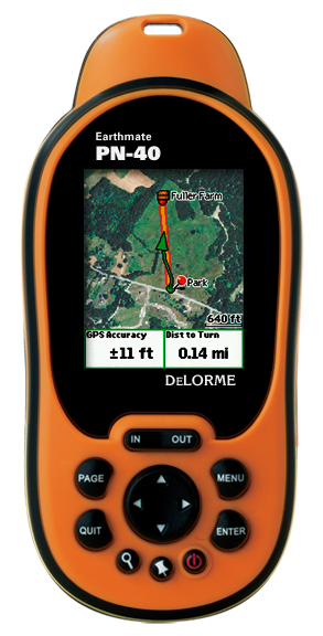
The DeLORME Earthmate PN-40
Earlier this year we got the DeLORME Earthmate PN-40 and have been very pleased and impressed with it since.
We can load color topo maps, color satellite and aerial images. You can be on a day trip and find mines that you
hadn't even planned out. Using the color aerial images is like having Google Earth with you in the field and can
be used to easily find tailing piles and mine buildings. See below for the features of the PN-40 and the other PN
series GPS units.

[web:ff769f0534]http://www.delorme.com//PN40/images/PNSeriesComparisonChart.pdf[/web:ff769f0534]- Craig -
Thanks!
It's really funny that that is the exact one I ended up buying today. I spent about two hours online looking at a whole bunch of ones. I really liked the Garmin 60cx, but everything I read said that Garmin Topo maps suck and didn't include BLM land. Kinda a no-go in Utah!
Did you purchase any more maps seperately, or are you just using the ones that came pre-installed?
Éirinn go BráchComment
-
I second the notion for this GPS. I have one and love it. The screen is kind of small, but I understand that with this many options the embedded video card probably can't handle a super large screen. The pre-installed maps suck so I would get XMap 6 Pro or Topo 8.0 and the Quads for Utah. If you get XMap Pro you can import 1-meter and 1-foot color imagery for free from the Utah GIS website.-Derek
Mojave Mine TeamComment
-
Great to hear that you got yourself a DeLORME. You wont be disappointed. In regards to the maps we purchased the $29.95 Map Library Annual Subscription. You can download as many maps as you like. It has worked great for us. Once you get familiar with the program for downloading and creating your map files you will be exploring everywhere and taking your DeLORME almost anytime you hit the road.
Here is a link to DeLORME's Map Library: DeLORME Map Library Annual Subscription- CraigComment
-
Cool.
Thanks for the info. I'll look into some mapping stuff tonight .
.
Éirinn go BráchComment
-
I've been playing with the software for a couple hours now trying to get a handle on it. It's a bit involved.
Is there a way to upload the Utah KMZ or CSV into it that you know of?
Otherwise, looks like I'll be adding alot by hand.
Éirinn go BráchComment
-
I like the DeLorme stuff as well and you can do firmware updates to them to keep the map and features up to date. I have an old GPS-3 and they supported that for quite a few years afterwards. It still works great!
MarkComment
-
The most popular brands are Garmin, Magellan, and Lowrance. By adding a mounting bracket, you can use a handheld GPS in your car too. As a matter of fact, there are brackets for mounting most GPS units on bicycles, motorcycles and boats. Unlike GPS units made for your car, most handhelds don't have voice prompts though, although some of them will "beep" as you approach your turn.
Handheld GPS units come in two types, mapping and non-mapping. Do you need a simple "non-mapping" GPS handheld unit just for finding your way back to the truck after a day of hiking? Or, do you need a "mapping" GPS you can use to map your trails, maybe plan your hiking paths days before your trip and download them from your PC to your GPS? A mapping GPS will have base maps, and allow loading additional maps into the unit. A non-mapping unit won't. Will you be using your handheld in the woods with a heavy canopy of leaves overhead? Some built-in antennas work better than others, but in deep cover, most will still have trouble seeing the satellites all the time. You might need a unit that can accept an external amplified antenna that can be attached to the top of your hat, or your backpack. Try it in the woods first and if you need one you can always add it later.Just like the car GPS, always consider the amount of internal memory your handheld unit comes with, because it will be the limiting factor when it comes to downloading detailed maps. More memory means more maps. Less memory just means you can't load as large of an area into your GPS. A very popular outdoor activity that requires a handheld GPS unit is Geocaching. Geocaching involves finding hidden treasure "caches" by using coordinates and direction-finding techniques enhanced by your GPS. Typically a cache consists of a waterproof container hidden from normal view that contains items left by previous Geocachers who have already found the treasure. Plus there's a logbook for signing after successfully finding the cache. Geocaching is a great family activity or for the sole adventurer who gets a thrill out of the hunt for hidden treasures!Comment
-
I was wondering what is up with that weird gravatar??? I know 5am is early and I'm not looking my best at that hour, but I hope I don't look like this! I might however make that face if I'm asked to do 100 pushups.Comment
-
We use Garmin Montana 650T. Put it in a grizzmo case and they are great. But pricey. around $550. You can dump all sorts of files and maps into them as well.Comment


Comment